 Inertial navigation, geo-reference and stabilization solutions
Civitanavi have designed products which are being used worldwide for making such “underground” alignments. Our flagship “Rig Aligner” product has evolved from an early Civitanavi marine navigation system, and has been optimized to provide a comfortable user interface using WiFi and a handheld display terminal (PDA). Accuracies from 0.05° to 0.5° are available, to suit performance and budget targets.
Also, we have again used our experience from the aircraft industry to bring “transfer alignment” to support these applications. In confined locations (such as an inclined underground drilling) it can be difficult making a measurement in a confined space with a traditional gyrocompass system (typically 7litres volume and 3-8Kg weight). To solve this, we have combined the benefits of MEMS Gyros, with the stability and accuracy of FOG Gyros to produce a product which is accurate and also easy to handle (portable 1litres, 0.8Kg) for these confined locations. Accuracies available are from 0.15° to 0.5°.
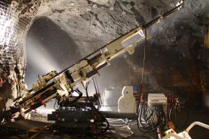
For higher performance applications, such as tunnel guidance, Civitanavi has developed a small footprint high accuracy gyrocompassing system. This product has a smaller form factor than our traditional product, without losing in accuracy. Heading accuracies down to 0.5mRad (0.025°) can be provided. This system is rugged and can perform an alignment when drilling.
Pipeline surveying is another “underground” application, where effectively an accurate positional survey (without GPS) is being made between defined fixed points. This relies on a stable inertial measurement unit (IMU).